Why North Atlanta Has Few Solar Farms — and South Georgia Has So Many
North Atlanta’s limited solar farms result from its hilly Piedmont terrain and suburban land use, while South Georgia’s flat Coastal Plain supports more large solar projects.
Get major local stories and development updates.
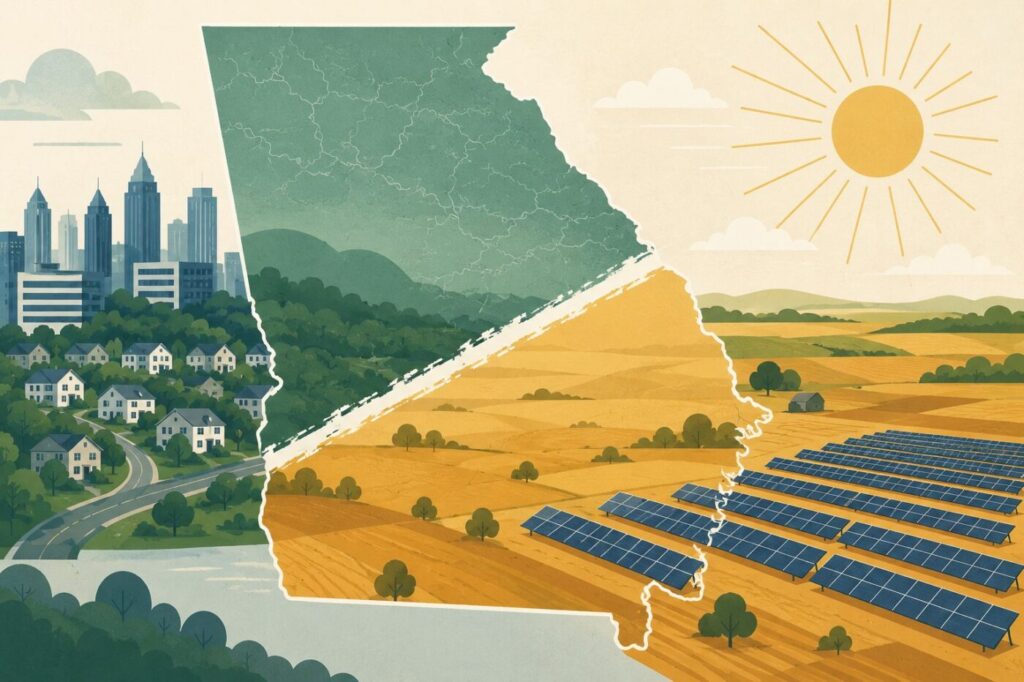
For readers in Johns Creek, Alpharetta, Milton, Roswell and South Forsyth, Georgia’s solar map can look almost counterintuitive. The state has plenty of sunshine everywhere, yet the large solar farms do not appear in the places most North Atlanta residents drive every day. They are far more visible below a broad diagonal boundary that cuts across the state from Columbus through Macon toward Augusta.
That boundary is not political. It is geological.
Georgia’s Fall Line is the old dividing zone between the Piedmont and the Coastal Plain, a roughly northeast-running transition where the land changes character. North of it, metro Atlanta sits in the Piedmont, with harder crystalline rock, rolling terrain, stream valleys, red clay, tree cover and a long history of dense suburban growth. South of it, the Coastal Plain begins, with broader, flatter land and larger agricultural and timber parcels. The line is not a perfect stripe on a map, but it has shaped Georgia’s cities, farms, roads and now its solar geography for generations.
The Solar Map Follows the Land
A recent Atlanta Journal-Constitution analysis found that nearly 90% of Georgia’s largest solar facilities are clustered below the Fall Line, where developers have found abundant, relatively flat land in South Georgia. The same article noted that these projects are often tied to rural counties where farmland, timberland and economic development pressures are part of the local debate.
That explains why a driver may see little or no utility-scale solar around Alpharetta or Johns Creek, but a very different pattern farther south. It is not that North Fulton or South Forsyth are unsuitable for sunlight. The issue is land. Large solar farms need wide, open tracts that can be assembled, permitted and connected to the grid without competing against subdivisions, office parks, shopping centers, schools, parks, country clubs and preserved neighborhood green space.
In North Atlanta, almost every large parcel already has a higher-value suburban use or a long line of possible future uses. A wooded tract in Milton or South Forsyth may become a conservation discussion, an estate-home development, a school site, a church expansion or a commercial rezoning fight. In South Georgia, large tracts of farm and timberland can still be assembled in ways that are difficult to imagine along McGinnis Ferry Road, Old Alabama Road, Windward Parkway or Peachtree Parkway.
Why the Fall Line Matters
The Fall Line marks where Georgia’s Piedmont gives way to the Coastal Plain. Rivers moving south from the harder Piedmont rocks historically dropped into softer Coastal Plain sediments, creating rapids, shoals and waterfalls that helped shape early settlement patterns. Columbus, Macon, Milledgeville and Augusta all grew near this transition zone because it was a natural break in travel, navigation and industry.
For today’s solar developers, the same old geography produces a modern land-use pattern. The Coastal Plain offers flatter terrain, broader parcels and a landscape already organized around farming, forestry and utility corridors. The Piedmont, by contrast, is hillier, more fragmented and more urbanized near Atlanta. That does not make one region better than the other. It simply means the economics of a large solar farm look very different near Alma, Camilla or Ocilla than they do near Johns Creek, Alpharetta or Suwanee.
North Atlanta’s Solar Future Looks Different
North Atlanta is more likely to see solar in smaller, built-environment forms: rooftops, parking-lot canopies, municipal buildings, schools, warehouses and commercial properties. Those installations fit a suburban landscape because they use surfaces that already exist. A grocery store parking lot in Alpharetta, a school roof in Johns Creek or a warehouse roof near Suwanee can host solar without transforming a large rural landscape.
That is the key difference. South Georgia’s solar story is about land conversion. North Atlanta’s solar story, if it grows, will be about reuse of existing space.
The distinction matters for local readers because it makes the solar map easier to understand. The absence of large solar farms around North Fulton and South Forsyth is not an accident, and it is not mainly about weather. It is about geology, terrain, land prices, parcel size and suburban density. Drive below the Fall Line, and Georgia opens into a different physical and economic landscape. The solar farms follow that opening.
If you’ve been following growth and change around here, these stories are worth a look too.
About the Author


In North Atlanta
What North Atlanta Should Know Today. Friday, Sept. 11, 2026
North Atlanta Courthouse Wedding Price Check: A Legal Marriage Can Start at $16

North Atlanta unemployment fell in July — but employment slipped in several communities

Why Sardines Are Disappearing From Some North Atlanta Shelves

When Are 2026 Property Taxes Due in North Atlanta?
What North Atlanta Should Know Today
IN NORTH ATLANTA